
T-RIS - Telonics Remote Imaging System and earlier APT efforts
In 1989 I was using the Texas Instruments TMS320C30 dsp processor in a large data acquisition system that I was designing at Syntron. Using one of the Syntron boards that I designed, along with an outboard a-d converter, I wrote a system to acquire the analog data from the low Earth orbit NOAA weather satellites. The satellite transmitted an FM signal which had a 2400 Hz carrier. The signal was received by a simple 137 MHz FM receiver with a crossed dipole antenna. The audio from the receiver was fed to the a-d converter. The analog data stream consisted of this 2400 Hz carrier amplitude modulated by the sync and data. The dsp software demodulated the data and even corrected for the slight Doppler shift on the 2400 Hz signal. The pictures came in as a line every 500 milliseconds. The motion of the satellite itself provided the y axis. The image below is an example captured from a morning pass of NOAA-10 showing hurricane Bob off the coast of South Carolina.
After writing the APT system to process data from the 137 MHz APT weather satellites, I started on the software to acquire and process data from the 1.7 GHz HRPT downlink from the same low Earth orbit NOAA birds. The hardware, built by Telonics in Mesa, Arizona, consists of a four foot parabolic dish on a rugged elevation azimuth mount with a down converter mounted at the focal point. I have about 100 of these systems in the field today. I wrote the entire software system including all of the graphics library, windowing system, and hardware drivers. The system was originally named TIRIS but Texas Instruments wrote us a nice letter asking us to change the name since they had a product that used it. The name was then changed to T-RIS. The system runs under dos with 16 bit assembly language routines for the data acquisition and a 32 bit dos extended section written mainly in C for the majority of the functionality. Windows was nowhere near a mature enough operating system to be used in early 1990 especially since the processors were running slower than 50 MHz. My Telonics dish and mount is shown in the following picture. It is automatically pointed straight up for minimum wind loading when not being used. Remnants of the summers banana crop can be seen in the lower left along with yagi antennas for 50 MHz and 1296 MHz.

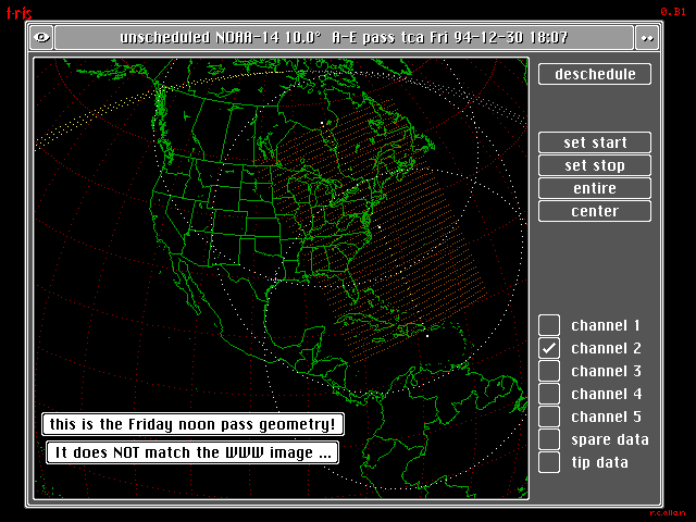
The 1.7 GHz signal is down converted to 137 MHz and this intermediate frequency is sent down a coaxial cable to a receiver/demodulator located in a standard PC chassis. The 600 kilobit/second data stream is then sent into the computer memory via the dma channel. My system calculates and displays upcoming passes graphically so that the operator may schedule desired areas to be imaged. The scheduling may also be completely automatic based on user parameters. The image below shows the pass geometry display. The black on white notes were added later. The pass visibility shown starts near Puerto Rico and extends into Canada. The brown grid is the area that will be imaged and saved.
While waiting for the next pass, a display of the current satellite position is shown.

During the satellite pass, which lasts about fifteen minutes, the system controls the dish antenna while collecting and displaying the data. As the pass is occurring, the display below is presented. The yellow dots represent the satellite track and are about 10 kilometers apart. The image scrolls up or down depending on the direction of the pass. This pass was from north to south and at the time of the image save was four minutes and fifty-five seconds before the end of the pass. The dish tracking error was 1.3 degrees and the satellite was 1760 kilometers from Houston at an altitude of about 800 kilometers.

A typical pass produces a raw image file of twenty to sixty megabytes. There are five separate channels of visible light and infrared data, each recording a different spectrum. After the pass is completed, the data may be then processed into images. The following visible light image is of hurricane Andrew in 1992 as it was leaving the Florida peninsula.

The overlay of geopolitical data on the images involves the calculating the exact image scan location by intimate knowledge of the satellite optics and orbit about the Earth. The mapping and gridding data is then projected onto the image. The original map data is known as the CIA World Data Bank. I purchased the data on a set of nine track data tapes as 80 column card images. I then processed the data with a program that I wrote for a Gould mini-computer. It compressed the data into a set of points that represented delta latitude and longitudes in arcseconds. Each map point was thereby crunched from eighty bytes down to an average of two bytes. After the compression and over an entire weekend, I transferred the data to a PC over a serial channel. This was before the days of CD roms and fast local area networks. And of course, no Internet as we know it today.
The system has an extensive set of functionality to produce maps for combination with the live data. In addition to the geopolitical database, a terrain data base called ETOPO5 provides elevation data at 5 arcminute resolution. The two data bases combine to produce images like the following.

The data from the NOAA orbiters can be accurately calibrated to show surface temperatures of the land, ocean, and cloud tops. My system made all of these calculations on each individual image and could display the results as shown below. Several of my systems are in place in Russia where they are used to search for forest fires. The image below shows the warm waters of the Gulf stream in the Atlantic Ocean off the east coast of the United States. The water directly off the coast around 50 degrees while the stream is about 70 degrees. Land surface temperatures in Florida that January day were 75 degrees or more. The cold cloud cover can be seen in the lower right corner.

The infrared sensors produced very exquisite images of various weather phenomena. The infrared image below shows cold lake effect moisture being picked up from the warmer (darker) lakes. This January image shows ice cover on parts of the lakes and the warm Mississippi River shows black against the Minnesota snow cover. Chicago can be seen a gray (warmer) smudge at the southwestern tip of Lake Michigan.

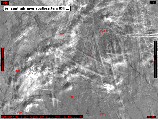
Very few man-made things can be seen with these kilometer resolution imaging systems. I have seen the bridge across Lake Ponchitrain north of New Orleans and some freeways around Houston when the conditions were just right. Boat wakes have been imaged from time to time. One of the most prominent features seen have been contrails from jet airplanes as seen below.
Built into the system were several quality control features. One of the important factors was the alignment of the parabolic dish antenna and feed. This alignment plot was made by stepping the 4 foot dish through an array of 1 degree points and collecting the relative solar noise level at each point. The resulting data allows fairly good determination of the antenna pattern pointing error.

Quality of the tracking system is checked by measuring the measured Doppler shift of the downlink signal against the predicted value.

...-.-